This exquisitely detailed map of Richmond is often referenced as being of Civil War vintage, but in fact it was produced after Lee’s surrender.
(The following is a slightly re-cast version of information from the PDF which describes the social history of the house at 2720 East Broad, Richmond, Virginia.)
June 11, 2025
The 12-mile square map of Richmond, Virginia, produced in the 1860s by Peter Smith Michie and his team is described in Richard W. Stephenson and Marianne M. McKee’s Virginia in Maps as “a superb example of the quality of maps that topographical engineers prepared when given the time to conduct the necessary field surveys.” They continued, “Depicted are such details as country roads, city streets, property lines, buildings, the names of households in rural areas, railroads, rivers and streams, and the Confederate batteries constructed to protect the city from capture. Topography is delineated by hachures – a series of lines in the direction of slope that, by their thickness and spacing, give an impression of relief.” [1]
Michie was born in Brechin, Scotland, in 1839, but immigrated to the United States with his family when he was a child, spending his boyhood in Cincinnati, Ohio. Appointed to the United States Military Academy at West Point, New York, he graduated second in his class of 1863. He was immediately deployed to the Union Army as a 1st lieutenant in the Army Corps of Engineers. He served first as an assistant engineer, then chief engineer of the Army of the James, and later as lieutenant colonel of volunteers and assistant inspector general for XXV Army Corps. In 1864, he was brevetted as brigadier general for meritorious services (brevet is a temporary promotion for outstanding service to a higher rank during times of need). From March 23 to July 1865, he was in charge of all engineer operations of the column on the left of the Army of the Potomac and was among the Union forces in pursuit of the Confederacy Army until the capitulation of General Lee at Appomattox on April 9, 1865. From April 9, 1865, to April 20, 1866, he was in charge of a team of eight fellow Union soldiers which would be sent to Richmond to make a survey of the theatre of operations around the city. He was in Richmond by April 24, first operating out of an office in the old Customs House but advertised on May 11 that he wanted to rent “two rooms well lighted for engineer office and draughting [drafting] room.” He apparently found it at the Medical College of Virginia at the corner of Marshall and 13th streets.[2]
The Puzzle of the Map’s Date and the Significance to the House at 2720 E. Broad
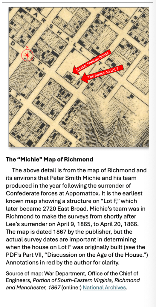
Because of the lack of other evidence, the map takes on an outsize importance as to a possible date of construction of the original footprint of the house at 2720 East Broad. It is often referenced as a “Civil War” map of Richmond, implying that it was produced during the conflict. If that were the case, then the presence of the structure (see sidebar) indicated by the small black rectangle, on what was Lot F and what would become 2720 East Broad, would indicate it was built before the end of the war, even, potentially, long before the end of the war. But, of course, U.S. Army cartographers did not enter Richmond to begin the official surveys for this map until around April 24, just after the Confederate surrender at Appomattox on April 9, 1865.
Documented sources say the Army surveyors were in the city until April 20, 1866.[3] Could there be any doubt about that particular date? The sources say Michie took a year’s leave after conducting the survey, but no information could be obtained as to where he was or what he was doing during that time. The map’s publication date, printed on the original document, is 1867. Was the map, then, in fact completed during the time the team was in Richmond? Could Michie have had concerns that the map needed further tweaks before publication and therefore had taken some time off to ensure that the map was polished up before publication?
Still another question arises: does the little rectangle really represent a completed structure on Lot F, or could it instead show the substantial ruins of a structure which had been built earlier – maybe decades earlier? The presence of Richmond’s “Burnt District” in the entirety of the map indicates that the surveyors did include structures that were severely damaged.
Conversely, instead of ruins, could the tiny rectangle depict the foundation of a new building in the process of being constructed?
Surprisingly, no significant research seems to have been done on Michie and the nuts and bolts of the production of this remarkable map of Richmond which might provide answers to such questions.
Some Biographic Details of Peter Michie
Michie married Maria Louise Roberts in Hamilton, Ohio, in 1863. After the war, he reverted back to first lieutenant from his brevet promotions but was promoted to captain when he returned to teach “natural and experimental philosophy,” as physics was then known, at West Point. He earned degrees from Princeton and Dartmouth universities and became a well-known and respected scientist. He published numerous scientific works, including “Wave Motion, relating to Sound and Light”(1882), “Analytical Mechanics”(1886), and “Hydromechanics”(1887). He also published “The Life and Letters of Emory Upton”(1885), which detailed the life of the Union general and military theorist. He served at West Point until his death at 61 in 1901.[4]
[1] Richard W. Stephenson and Marianne McKee, Virginia in Maps: Four Centuries of Settlement, Growth, and Development (2000: The Library of Virginia), pp. 194 and 213.
[2] Biographic sources: “Death of Professor Michie,” The Dayton Herald (Dayton, Ohio), February 16, 1901, and George W. Cullum, Biographical Register of the Officers and Graduates of the United States Military Academy (publisher unknown: 1891) transcribed online at https://penelope.uchicago.edu/Thayer/E/Gazetteer/Places/America/United_States/Army/USMA/Cullums_Register/1996*.html. Newspaper sources that Michie was in Richmond: “Official Directory,” Richmond Whig, April 24, 1865, and classified advertisement, “Wanted to Rent,” Richmond Times-Dispatch, May 11, 1865. End date in Richmond was taken from Cullum.
[3] Cullum.
[4] “Peter Smith Michie,” findagrave.com, accessed October 29, 2024, and “Michies Abroad Peter Smith” family tree, ancestry.com, accessed October 29, 2024.
